Longshore transport of sand and the Oceanside Littoral Cell
Longshore sand transport is the process that moves sand parallel along a beach or coastline. Waves generally approach the shoreline at an angle. When the waves rush up the beach, they move the sand upwards at an angle to the shoreline. When the water rushes back offshore, it is governed by the force of gravity, which acts perpendicular to the shoreline. This small difference causes the sand to move in a zig-zag pattern within the "swash zone." The long-term result is a net movement of sand parallel to the coast known as longshore drift (also sometimes called littoral drift -- ("littoral" means "nearshore.")
This same process also creates an alongshore movement of water known as a longshore current -- which many beachgoers have experienced as they bob up and down in the nearshore, returning to shore to find themselves far downcoast from where they started.


Within southern California, this process moves sand predominantly from north to south, pushed by the prevailing waves from the northwest. The crashing waves push the sand onto the beach; sand is then dragged offshore in the swash zone, before being pushed back onto the beach again. When the wave direction is from the south, as happens often during the summer, sand is moved in the opposite direction, from south to north.
In 1960, Inman & Chamberlin described a theoretical model of large-scale longshore drift patterns in southern California. He envisioned a series of "littoral cells" bounded by rocky outcrops that hindered the downcoast transport of sand. Sediment flowed into the cells from streams and other sources, moved southward through the cell, and ended at a submarine canyon. The canyons trend roughly perpendicular to the coastline, with the head of the canyon lying within the nearshore zone. The canyon thus captures the sand flowing downcoast. After the sand falls down into the canyon, it flows far offshore and is no longer available within the nearshore system.
San Clemente lies within the Oceanside Littoral Cell which begins just south of Newport Submarine Canyon and extends through north San Diego county down to the La Jolla Submarine Canyon. The net longshore transport of sediment within this cell is estimated at 275,000 cubic meters of sand per year (SANDAG 2007).
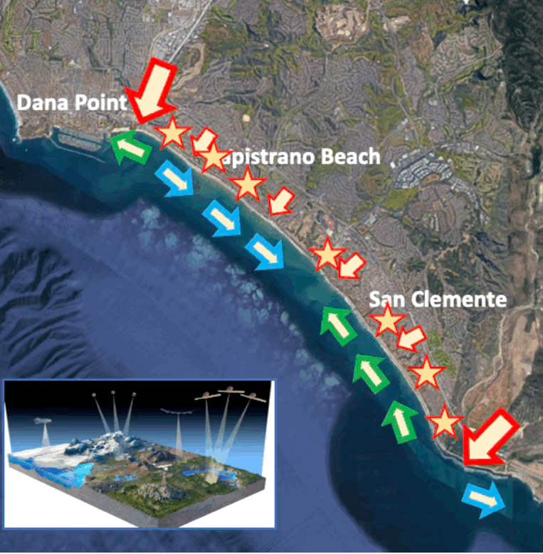
San Clemente has a bi-directional longshore drift pattern
San Clemente’s shoreline generally trends northwest to southeast, with the northern half of the city facing slightly more southward, and the southern portion facing slightly more northward.
As discussed in the last section, waves approaching our shoreline tend to bend to become perpendicular to the bathymetric lines. As result, the direction of longshore drift tends to be towards the south across the northern 2/3 of our city’s coastline, and to the north across the southern third, with back-and-forth movement across smaller areas.
,The figure to the left illustrates modeled sediment flux where positive numbers indicate northward transport.
When the swell approaches from the southwest, generally occurring during the late summer, even stronger northward bound longshore currents arise.
In summary, San Clemente tends to experience southward longshore drift during the winter and northward longshore drift during the summer, especially heightened in the southern end of the city.

The Capistrano Bight can be considered a closed “mini-cell”
This figure illustrates the conclusions of recent work done at University of California Irvine’s Flood Lab under the direction of Dr. Brett Sanders.
This research (shown above) indicates that because the south end of San Clemente has a net northward direction of longshore drift, little sand will escape from this system, and it should be considered a closed “sub-cell” within the Oceanside Littoral Cell.
This distinction is important as it would appear that sand retention structures within this mini-cell would not have an impact upon shorelines further south, as none of this sediment would be expected to be transported south of San Mateo Headland anyway.