

Most of our swell is generated from long distances

Although some of the waves affecting our coastline arise from winds generated by local storms, most of the swell reaching our shores arises from storms far away.
Swell generated in the South Pacific, from storms spanning south of Australia to well east of New Zealand are responsible for most of the waves reaching our coastline for much of the year. The summer months being the largest. These storms generate long-period swells with approach angles ranging from south to southwest, which is the ideal direction for San Clemente, with our coastline’s general orientation exposed in this direction.
Winter swells are generated in the North Pacific. These swells are mostly low to moderate in height along San Clemente beaches (due to offshore island shadowing and coastal orientation); unless the storm track dips south, creating a more westerly approach angle, then these swells can be large.
During the late summer and early fall we can get swell from hurricanes that form off the coast of mainland Mexico, generally from the south/southeast. With the sharp approach angle, strong alongshore currents are common that sweep to the north.
Locally generated waves occur before (South/Southeast), and following (West/Northwest) the passage of winter cold fronts, which can generate high seas and large sloppy surf. It is during these events that strong alongshore currents are generated due to the sharp approach angle of the incoming waves.
Offshore features dramatically change these waves
The Southern California Bight is a unique geographic area characterized by a series of deep ocean basins separated by ridges, some of which rise above the waterline as the Channel Islands.
As waves pass over this complex bathymetry, they become refracted, meaning that they change direction. So waves coming in from the northwest, for example, may actually enter our coastline from a westerly direction. Upon entering the Capistrano Bight, these waves have conformed to the bathymetry, and approach from the west southwest to southwest.
As shown in the diagrams below, the islands also create “wave shadows” or areas of decreased wave energy on the coast. The offshore islands act as a significant block to wave energy, and this is why sometimes there are reports of large offshore waves which our local coastline does not experience.
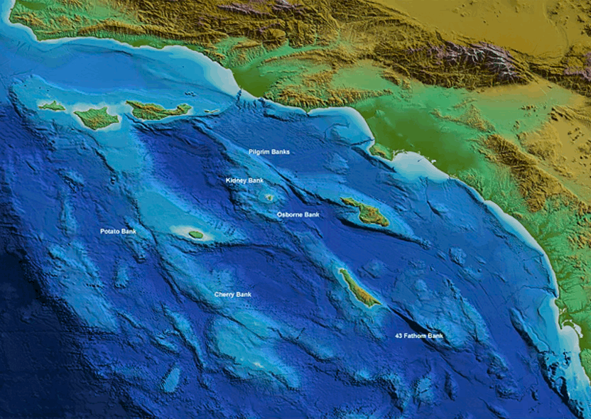
Point Conception and the offshore islands blocks significant wave energy coming from the northwest, and less so for waves entering from the west; Catalina hacks away the brunt from westerly swells. Winter swells from the west and northwest are generally reduced by 50-90% by the time they reach just offshore of San Clemente, depending on the original deep water direction and period. This is almost entirely due to the offshore island shadowing, and complex refraction and diffraction processes. However, the resultant energy reaching San Clemente can be significant at times since the winter swell heights can reach great heights over offshore waters, making that reduced percentage reaching the beach still large. This becomes particularly acute during El Niño years when the North Pacific storm track often lowers in latitude, creating more westerly swells with greater energy reaching San Clemente beaches.
Our coastline is somewhat shielded from swell coming from the south-southeast, but receives much more energy from waves entering from the south-west, which are not impeded by islands or headlands. (Data and analysis provided by Charlie Fox 2024)
Catalina Island effectively blocks wave energy coming from the northwest, and less so for waves entering from the west. Swells from the northwest are generally reduced by 50-90% by the time they reach just offshore of San Clemente, depending on the original deep water direction and period. This is almost entirely due to the offshore island shadowing, and complex refraction and diffraction processes. However, the resultant energy reaching San Clemente can be significant at times since the winter swell heights can reach great heights over offshore waters, making that reduced percentage reaching the beach still large. This becomes particularly acute during El Niño years when the North Pacific storm track often lowers in latitude, creating more westerly swells with greater energy reaching San Clemente beaches.

As a result, the majority of our waves approach our shore from the southwest

As described above, we are generally shielded from waves approaching from the southeast and northwest. This means that most of our waves come from the southwest. However, even waves that are generated to the west or northwest of California have to bend around south of Catalina to enter into the Capistrano Bight.
Additionally, Dana Point acts to locally shadow waves coming from the northwest. So even if winter storms generate large waves, San Clemente often does not experience big sets to any significant degree.
Nearshore bathymetry causes the direction of waves to bend, either focusing or dissipating energy in different areas
The water within waves travels in an orbital pattern, and that movement extends below the water surface to a depth equivalent to half the wave’s length (the distance between wave crests). As waves enter into shallow water, that movement begins to interact with the seafloor and the friction causes the wave to slow down. If the wave is approaching a straight coastline at an angle, the side of the wave that first hits the coast will slow down first, causing the wave to eventually bend.
Other bathymetric features also cause bending — waves tend to bend towards headlands, focusing energy there and increasing erosion. Alternatively, as waves pass over submarine canyons or into wide bays, they tend to bend outwards and dissipate their energy.
Data and analysis below provided by Charlie Fox 2024.
More details on wave refraction can be found here.

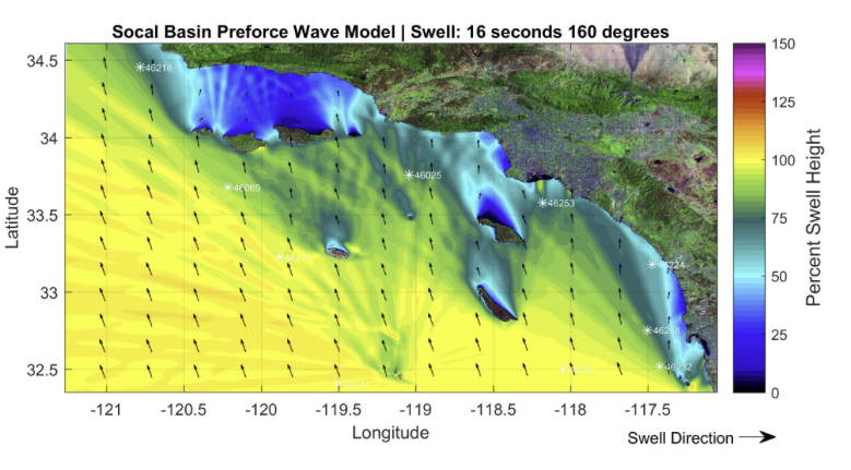
These images illustrate swell originating from the northwest, showing reduction by 50-90% by the time they approach San Clemente’s shoreline, resulting in almost no significant waves at our coastline.
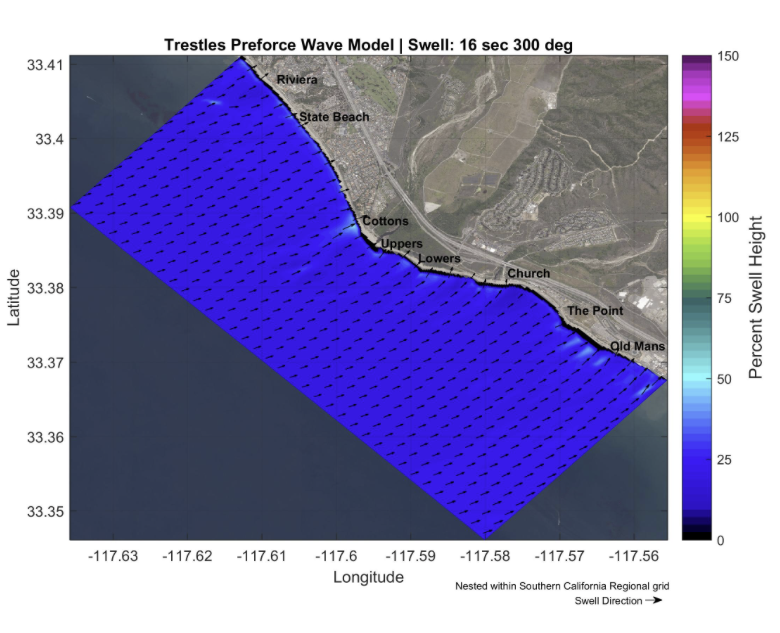
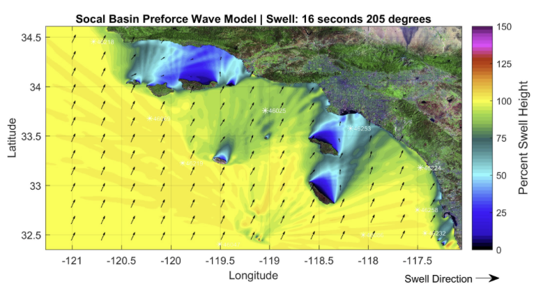
These images illustrate a swell originating from directly west. Note the increase in swell reaching the beaches, relative to the example above, nearly 50% of the open-water swell. Right, high resolution model run showing focusing along bathymetric features, particularly near Cottons, creating larger surf.

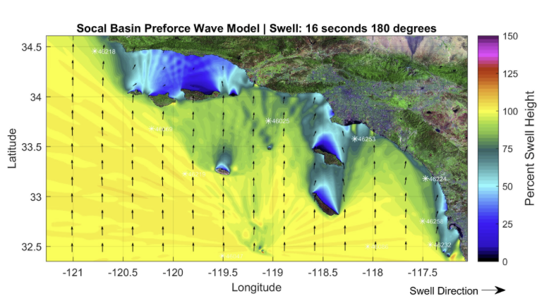
These images illustrate swell originating from directly south, and a high-resolution model showing the focusing along bathymetric features. Note the high refraction at Cottons Point. These waves will break left, generating strong northbound currents. At all other locations, waves will break parallel to the coastline.

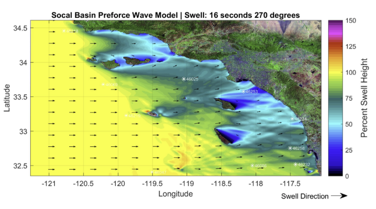
These images illustrate swell originating from the southwest, showing even greater wave energy at approach to our shoreline due to the lack of shadowing.
