

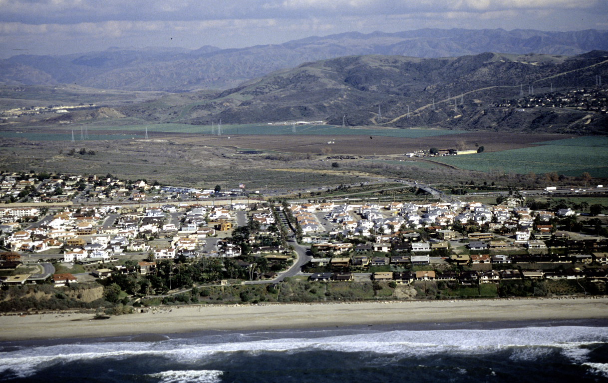
San Clemente State Beach
State Beach lies just north of Cyprus Shores, and the accelerated erosion apparent at Cyprus Shores has been moving northward into State Beach. There is zero width of dry sand at the southern end of State Beach.  There is zero width of dry sand at Calafia Beach Park.  Other areas have less than 50 feet of dry sand, the minimum necessary buffer between the ocean and the railroad's rock revetment to prevent accelerated erosion.  Immediate action to replenish sand at this location is necessary in order to save this beach for future generations.

ARMORING: OCTA has established revetments between 10 to 50 feet wide across this stretch of coastline and continues to add to those revetments, as recently as March 2023. It has requested a Coastal Development Permit in 2023 to "replenish" revetment at Calafia.

UNIQUE CHALLENGES: This is the most-threatened public recreational beach in San Clemente.  The primary challenge here is jurisdictional. The City is motivated to restore its beaches, and has undertaken the burden of paying for a Feasibility Study for this beach; however, State funding must be obtained for its restoration. State officials apparently are mostly interested in preserving hard infrastructure -- and because all of that infrastructure is behind the railroad, it is not currently threatened.

SEDIMENT CHARACTERISTICS: Most of the sand is underwater. The remaining wet sandy beach is composed of medium-to coarse-grained sand, with an offshore cobble field and periodically-appearing cobble cusps.

INFRASTRUCTURE: Except for movable lifeguard towers, all of the infrastructure, including restrooms, concessions, parking, and all of the campground facilities, lie behind the railroad and therefore are under no immediate threat (as long as the railroad revetment is present).

PUBLIC ACCESS: Calafia is a popular public beach with abundant parking. The San Clemente State Beach Campground is one of the most popular in California and is generally fully booked a year in advance.

SURF RESOURCES: need Joe's input here
The images below illustrate the evolution of San Clemente State Beach, which remained from 1979 through 2010.

Cyprus Shores 1979
Cyprus Shores 1989

Cyprus Shores 2004

Cyprus Shores 2019

Cyprus Shores 2021
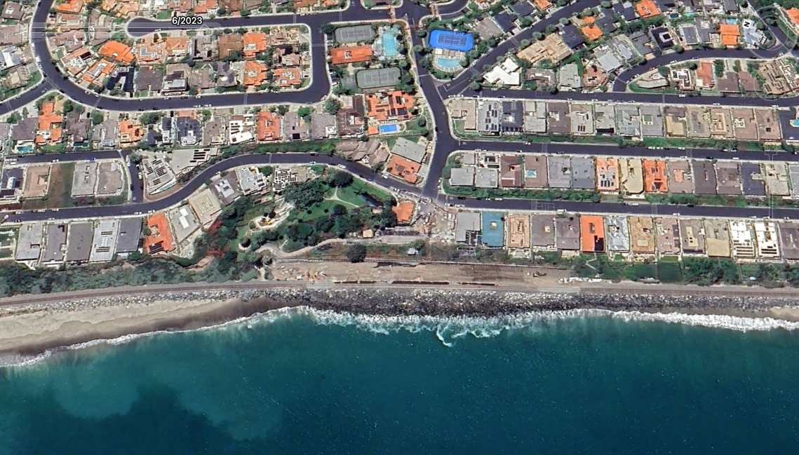
Cyprus Shores 2023
The image below illustrates changes in the beach profile at one location, the pedestrian underpass at the State Park campground.
It should be noted that Save Our Beaches has also measured the beach width at this location and cannot validate these results. After conversations with the City’s consultant, it appears that they had included the railroad’s rock revetment as part of the “beach” which they agreed was inappropriate. Hopefully this will be corrected in the future. Meanwhile, we do not have confidence in this profile.

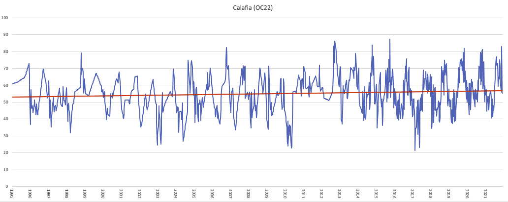
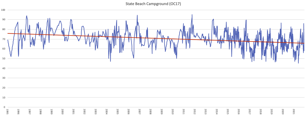
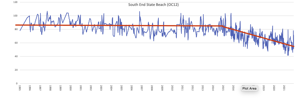
Below, data from UC-Irvine demonstrate the differences in beach width variation between the northern and southern portions of the State Beach. At Calafia, there has been a slow growth between 1995 and 2021, countered by a gradual narrowing at the beach adjacent to the campground. The south end of the State Beach exhibits the same pattern as Cyprus Shores. Historically, the sand that was lost offshore was always eventually brought back to the beach, until an event happened around 2015 (two years later than the accelerated erosion at Cyprus Shores, showing the gradual movement of erosion northward). According to Dr. Brett Sanders, the “tipping point” here was that the beach reached a critical width where storm waves began to crash against the railroad’s rock revetment, creating additional turbulence and increasing the rate of erosion, resulting in the complete loss of beach.
Note that erosion has also accelerated at Calafia beach, in the winter of 2023/24 there is no dry sand at high tide.
Gallery of historical photos from San Clemente State Beach prior to 2015. (these are place-holders, need to get better ones, maybe about nine total).


Another gallery of recent photos.